- April 12, 2022
- Posted by: EARSC
- Category: Members News
All trees in Poland on one map
– Regional Tree Crown Map™
As science advances, we see more and more clearly the huge role trees play in the functioning of the entire biosphere, particularly by stabilizing the Earth’s climate. The large-scale process of photosynthesis means that forests can supply more than half of the annual oxygen needs of humans and animals. Trees also contribute to the reduction of greenhouse gases – thus helping to reduce global warming and regulate the negative effects associated with the urban heat island. In the light of the still increasing degradation of the natural environment, the contribution of trees to the neutralization of man-made atmospheric, water, and soil pollution is also not without significance. The multitude of roles that trees play in the environment makes effective and rational management of greenery an indispensable tool for improving the quality of the entire ecosystem, and this could not be done without their detailed inventory.
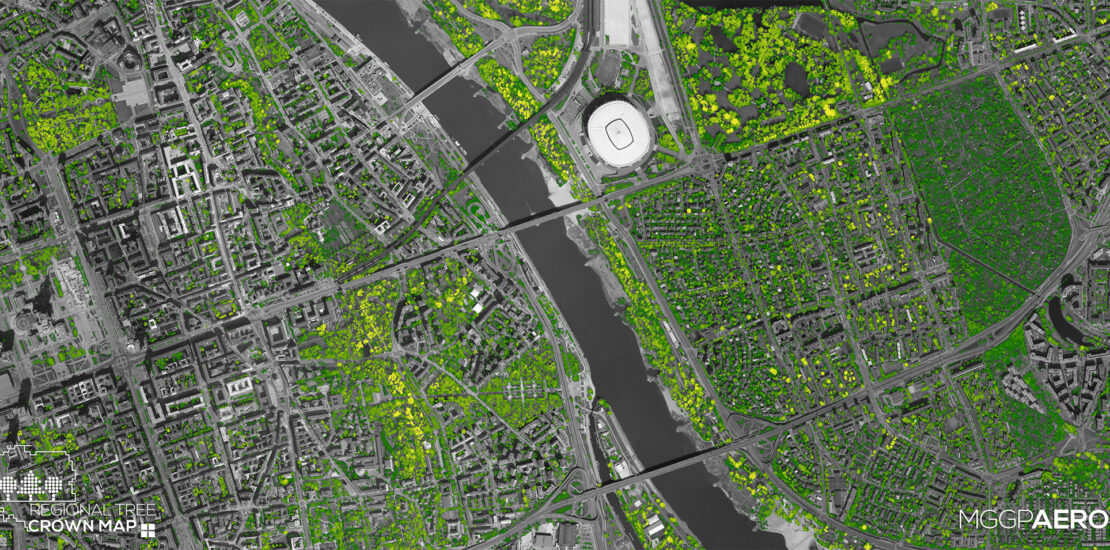
However, how to obtain reliable knowledge about the distribution of several million trees across the country? The modern technology of remote sensing proved to be irreplaceable in this context. This is a type of research performed remotely (e.g. from a satellite or airborne level), using specialized sensors (cameras, laser scanners, etc.). The possibilities created by this kind of research have been used by MGGP Aero company to conduct an inventory of all trees in Poland. The release of free airborne laser scanning (ALS) data by the Head Office of Geodesy and Cartography in July 2020, combined with many years of experience in working with this type of data, enabled MGGP Aero specialists to prepare a comprehensive study, performed with fully automatic methods, presenting the distribution of trees across the country. As a result, more than 3.3 billion tree crowns visible from above were inventoried, covering a total area of 96 694,76 km2, which is 30.92% of the country’s land area. The results were presented as the Regional Tree Crown Map™ and made available on the My Tree Map™ website (https://mytreemap.com/).
New solutions to contemporary problems
Currently, the development of the region is determined not only by the economic potential or the level of qualification of the local community but also by the quality of living and working environment, including green areas. Not only natural and managed forests, but also small woodlands or even single trees are important in this context. Monitoring the parameters of individual trees is an increasingly important aspect of greenery management because it allows gaining the knowledge necessary to make decisions leading to the sustainable development of green areas.
To meet needs, the My Tree Map™ website published in October 2021 and the Regional Tree Crown Map™ provided users with comprehensive spatial information about trees, presenting some tools to build knowledge about both individual trees and larger green space complexes, regardless of land cover type or land ownership. Through the use of aerial remote sensing methods, the Regional Tree Crown Map™ presents information not only about the location, but also about the height of trees and the area and volume of their crowns, and what is more, this information is homogeneous and consistent for the whole country. The analysis included all trees seen from above, not obscured by higher crowns, meeting the parameters of minimum height equal to 4 m and minimum crown area of 9 m2. By reading the Regional Tree Crown Map™ and analyzing changes in parameters of location, height, and area of tree crowns, it is possible to monitor natural processes, monitor secondary succession, assess the effects of active protection, and monitor economic activity in forests. Moreover, by ordering detailed local maps, such as Local Tree Species Map™ or Local Tree Health Map™, it is possible to obtain information about forest species composition, assess the health status of particular trees, and identify dead trees.

Fig. 1. Tree parameters available within the Regional Tree Crown Map™ including the unit and precision of the individual parameter.
However, the problem now is not only the drastically decreasing number of trees but also the lack of public information about the resources of green areas. The Regional Tree Crown Map™ as a generally available, largely free tool, provides an opportunity for all citizens in Poland to know the location of each tree and its parameters. Such a solution allows us to obtain comprehensive information, showing the diversity of trees in any selected space, in a very fast way.

Fig. 2. Depending on the display scale, trees are presented: a) as individual crowns aggregated into eight height classes (1:1 000 – 1:150 000); b) as a cartogram showing the percentage of a crown area within administrative unit boundaries, divided into seven classes (1:150 000 – 1:4 000 000).
The data offered as part of the service opens a wide range of possibilities for GIS spatial analysis in the field of comprehensive green area monitoring. The implementation of appropriate geospatial operations allows for the identification of trees including their value or assessing threat, such as specimens growing in collision with infrastructure elements. Parameters such as the location and area of the crown also make it possible to examine the location of trees in relation to agricultural parcel boundaries, identify free-standing specimens with a given crown diameter, as well as to calculate the area of mid-field coppices.
Knowing the actual height and area of the crowns, it is possible to calculate the amount of biomass, the amount of oxygen produced or carbon absorbed. The choice of automatic methods for acquiring and processing information makes it easier than ever to spot relationships that are not visible at first glance and to make the right decisions based on objective data analysis in a GIS environment.

Fig. 3. The interface of the My Tree Map™ website with the Regional Tree Crown Map™ product.
Free access to the Regional Tree Crown Map™ allows you to: read individual tree crown parameters, calculate simple statistics at any location within a user-defined range.
The Regional Tree Crown Map™ is available on the My Tree Map™ website, which is an information and education platform about trees and their role in the world around us. Free access to the National Tree Crown Map™ enables: reading the parameters of individual tree crowns, calculating simple statistics in any location within a user-defined range. It is also possible to download vector data that can be implemented into the GIS environment of your choice for further analysis.
