- December 17, 2021
- Posted by: EARSC
- Categories: Members News, Uncategorised
What started as a yield prediction and monitoring tool for the Belgian potato sector has grown into an open and holistic platform that supports the entire agricultural sector. WatchITgrow is ready for Interpom 2021, to show you the value and importance of combining data, using the newest data technologies, and to connect tools and players over the entire industry to strengthen our position in an agricultural market which is adopting to the digital transformation at a rapid pace. Let me explain how we support both farmers and industry in the transition towards a sustainable agriculture as set forward by the rules of the European Green Deal.
SERVING THE POTATO SECTOR FOR MORE THAN 5 YEARS ALREADY
In 2022, WatchITgrow will be serving the potato sector in Belgium, The Netherlands, France and Germany for 5 years already. In these 5 years, the platform has changed from a yield prediction and monitoring tool for the Belgian potato market towards an open and holistic platform that supports the agricultural sector in maintaining its growth whilst at the same time improving its sustainability.
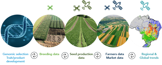
Throughout the years WatchITgrow shifted its focus towards creating a so called ‘digital twin’ of any field. By combining all possible data sources (satellite, weather, soil, field, machinery data, …) and using new technologies such as big data analytics, machine learning, etc., WatchITgrow provides farmers with more personalized advice which allows them to sustainably increase their yields.
A SHIFT FROM TRADITIONAL SIMULATIONS TO BIG DATA MODELS
The digital transformation has reached nearly every aspect of society and business, including of course the agricultural food system which is adopting at a rapid pace. Digital innovations offer the potential to drastically improve yields, sustainability and farmers income.
To support this digital transformation we also need to shift from traditional crop growth simulation models to big data models. To train these models large amounts of field data are needed. The base data layer for every field remains the satellite derived information. These objective measurements deliver us information over time on the growth and health of the crops on the field, as influenced by crop species/variety and agro-ecological conditions such as soil type, nutrients, and local weather.
Read more at https://blog.vito.be/remotesensing/watchitgrow-connects
