- September 29, 2021
- Posted by: EARSC
- Category: Members News

25 years of successful cooperation between GAF AG, DLR and Antrix
GAF, the German Aerospace Center (DLR) in Neustrelitz and Antrix Corporation have a successful cooperation stretching back 25 years. In 1996, they signed agreements for the purpose of receiving Indian Earth observation data and distributing the data to European customers on an exclusive basis. That was the starting point for 25 years of successful cooperation and the acquisition of millions of scenes so far – and on into the future.
Neustrelitz, Germany, 28 September 2021
The cooperation between the GAF subsidiary Euromap GmbH, DLR and Antrix began in 1996 with the signing of various agreements. The purpose: to receive Indian Earth observation data and distribute this data to European customers on an exclusive basis. In order to handle the processing, storage and provision of the data, GAF formed the wholly owned subsidiary Euromap GmbH on the DLR campus in Neustrelitz. GAF and Euromap merged in 2014.
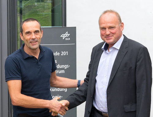
“We are very proud of the now already 25 years of successful cooperation with our long-standing partners, the German Aerospace Center (DLR) and Antrix Corporation of the Indian Space Research Organisation (ISRO),” emphasised Dr. Sebastian Carl (Managing Director of GAF) during a meeting with Holger Maass, Department Head of the National Ground Segment of DLR at the DLR campus in Neustrelitz, Mecklenburg-Vorpommern.
Using the antennas and the operational experience at the DLR national satellite data receiving ground facility in Neustrelitz, the partners started with the reception of data from the Indian IRS-1C remote sensing satellite, which was launched in 1995. So far, the partnership has included six satellite missions. Thanks to both the ambitious Indian EO programme and the common understanding reached between Antrix and GAF, the partnership is also set to be expanded further. It has paved the way for the first commercial provision of remote sensing data in Europe for mapping, state planning and ecological research.
To date, GAF has acquired and archived more than 1.4 million scenes covering almost 40 billion square kilometres with medium, high or very-high resolution IRS optical satellite raw data. Furthermore, GAF has acquired roughly 26,000 scenes covering 38 billion square kilometres with low resolution data from the Oceansat-2 Ocean Colour Monitor. GAF has provided data products and related services to, for example, the Joint Research Center (JRC) of the European Commission and the European Space Agency (ESA) for the Copernicus and Earthnet programmes.
Holger Maass concludes, “GAF and DLR share spatial proximity and a professional alliance in Neustrelitz. It is an excellent example of a partnership between a scientific organisation and a private company. Over the 25 years of our cooperation, our technical progress has accelerated and the speed of the rollout of our remote sensing services has increased.”
Antrix Corporation expresses its deep appreciation regarding the way this partnership has been taken forward by GAF AG. Antrix is looking forward to continuing its association with GAF and DLR and wishes all the stakeholders a successful future.
This Press Release has about 3.167 characters.
About Antrix – India:
Antrix Corporation Limited (ACL), incorporated on 28 September 1992 (under the Companies Act, 1956) is a wholly owned Government of India company, under the administrative control of the Department of Space (DOS). Antrix is the commercial arm of Indian Space Research Organisation (ISRO) and is responsible for the promotion and commercial exploitation of the products and services resulting from the Indian Space Programme. The Company was awarded ‘MINIRATNA’ status in 2008.
About DLR – Germany:
The German Remote Sensing Data Center (DFD) is an institute of the German Aerospace Center (DLR). Together with the centre’s Remote Sensing Technology Institute (IMF), it comprises DLR’s Earth Observation Center (EOC), which coordinates DLR’s activities relating to Earth observation data from satellites and aircraft. DFD focuses on the reception, archiving, distribution and utilisation of data.
In addition to applied research, DFD has expertise in the development and operation of satellite ground systems.
About GAF AG – Germany:
GAF AG is an e-GEOS (Telespazio/ASI) company located in Munich and Neustrelitz, Germany. It is a leading geo-information company with an international reputation as a skilled provider of data, products and services in the fields of geo-information, spatial IT and consulting for private and public clients. As a result of a merger with its former subsidiary Euromap GmbH, GAF has become the exclusive supplier in Europe of optical Indian Remote Sensing data from several missions. The company’s archives contain systematic coverage of Europe and northern Africa from 1996 and onwards, and include satellite raw data from the high and medium resolution IRS missions IRS 1C, IRS-1D, Resourcesat-1, Resourcesat-2 and Cartosat-1. GAF is also specialised in the production of orthoimage mosaics and digital elevation models from various high and very-high resolution satellite missions.
To obtain more information, please contact:
| GAF AGDaniela MillerArnulfstr.19980634 MunichTel.: +49 89 12 15 28-0 info@gaf.de | www.gaf.de | German Aerospace CentreGerman Remote Sensing Data CentreDepartment: National Ground Segment Tel.: +49 3981 480 111 Holger.Maass@dlr.de |
